Wednesday, September 22, 2010

Typhoon Malakas regains more strength as it moves toward Iwo To-Chichijima area


Typhoon Malakas (13W)
  • 19.8N 141.0E
  • 546.34 km. South of Iwo To, Japan
  • currently moving west-northwestward @ 7 kph
  • maximum sustained winds: 120 kph
  • gustiness winds: 148 kph
  • Saffir-Simpson Typhoon Scale: Typhoon
  • minimum sea level pressure: 989 MB
  • maximum sea wave height: 23 feet
  • heading towards Iwo To-Chichijima area
Extended Forecast Outlook:

12 hours
  • 21.4N 140.7E
  • maximum sustained winds: 139 kph
  • gustiness winds: 167 kph
24 hours
  • 24.0N 140.9E
  • maximum sustained winds: 167 kph
  • gustiness winds: 204 kph
36 hours
  • 26.9N 141.8E
  • maximum sustained winds: 167 kph
  • gustiness winds: 204 kph
48 hours
  • 31.8N 144.4E
  • maximum sustained winds: 148 kph
  • gustiness winds: 185 kph
72 hours
  • 42.2N 154.5E
  • maximum sustained winds: 139 kph
  • gustiness winds: 167 kph
96 hours
  • 50.7N 167.9E
  • maximum sustained winds: 102 kph
  • gustiness winds: 130 kph
  • Extra-Tropical Cyclone
* All forecast outlook are taken from Joint Typhoon Warning Center

Tuesday, September 21, 2010

Tropical Storm Malakas/13W consolidating more strength as it moves closer to Iwo To-Chichijima area


Tropical Storm Malakas (13W)
  • 19.5N 142.5E
  • 601.9 km. South-Southeast of Iwo To, Japan
  • currently tracking west-northwestward @ 15 kph
  • maximum sustained winds: 74 kph
  • gustiness winds: 93 kph
  • Saffir-Simpson Typhoon Scale: Tropical Storm
  • minimum sea level pressure: 993 MB
  • maximum sea wave height: 15 feet
  • heading towards Iwo To- Chichijima area
Extended weather forecast:

  • Thursday -102 kph-Tropical Storm
  • Friday-139 kph-Typhoon/Category 1-expected to pass Iwo To area early morning
  • Saturday-158 kph-Typhoon/Category 2
  • Sunday-102 kph-Tropical Storm

Monday, September 20, 2010

Tropical Storm 13W (Malakas) gaining more strength...Tropical Wave approaching Eastern Philippines


Tropical Storm Malakas (13W):*Relocate
  • 18.4N 145.3E
  • 351.88 km. North of Saipan
  • currently moving west-southwesward @ 7 kph
  • maximum sustained winds: 65 kph
  • gustiness winds: 85 kph
  • Saffir-Simpson Typhoon Scale: Tropical Storm
  • minimum sea level pressure: 996 MB
  • maximum sea wave height: 12 feet
  • heading towards Iwo To-Chichijima area
Tropical Storm 13W is expected to move in westward-west-northwestward direction within the next 36 hours packing the maximum sustained winds of 75 kph-111 kph. It will then resume it's track to northeast-northnortheastward direction starting this Thursday peaking the wind speed of 139 kph (Category 1) towards Iwo To, Japan area. This coming Saturday, it is anticipated to pack the maximum sustained winds of 167 kph (Category 2) as it forecasts to remain its track in northnortheastward direction.

Proper precautionary measures must be implemented especially the Northern Marianas, Iwo To-Chichijima area and the rest small islands of Japan.

WEATHER UPDATE IN THE PHILIPPINES

Tropical Wave fastly approaching towards the Eastern coast of our country.

Possible affected area:
  • Bicol Region
  • Visayas
  • Mindanao
Proper precautionary measures must be prepared as this might bring widespread light-moderate rains with possible thunderstorms that would trigger flash floods and landslides.

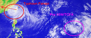
Typhoon Fanapi re-intesifies as it made its second landfall...Pre-13w rapidly gaining more strength


Typhoon Fanapi (12W/Inday)
  • 23.9N 117.6E
  • 388.92 km. East-Northeast of Hong Kong, China
  • currently moving west-northwestward @ 24 kph
  • maximum sustained winds: 120 kph
  • gustiness winds: 148 kph
  • Saffir-Simpson Typhoon Scale: Category 1
  • minimum sea level pressure: 970 MB
  • maximum sea wave height: 24 feet
  • heading towards Southeastern China
Tropical Cyclone Formation Alert 90W/Pre-13W
  • 18.0N 146.7E
  • 324.1 km. North-Northeast of Saipan
  • currently moving northwest @ 22 kph
  • maximum sustained winds: 28 kph
  • gustiness winds: 37 kph
  • minimum sea level pressure: 1007 MB
  • forecats for the next 12 hours: Minimal Tropical Depression

Saturday, September 18, 2010

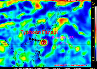
Typhoon Fanapi now lossing it's strength as it transverse Central Taiwan, 90W now the subject for TCFA


Typhoon Fanapi (12W/Inday)
  • 23.7N 121.6E
  • 148.16 km. South of Taipei, Taiwan
  • now made on it's landfall
  • currently moving westward @ 26 kph
  • maximum sustained winds: 195 kph
  • gustiness winds: 241 kph
  • Saffir-Simpson Typhoon Scale: Category 2
  • minimum sea level pressure: 952 MB
  • maximum sea wave height: 28 feet
  • heading towards Taiwan Strait-Southeastern China
Typhoon Fanapi weakens it's strength as it made its landfallo ver the Eastern coast of Taiwan downgraded in to Category 2 disturbance. It is anticipated to resume its westward track this afternoon and will be expected to be in Taiwan Strait later tonight with the maximum sustained winds of 165 kph. Stormy weather with thunderstorm and storge surge is expected to affect across the island nation. Typhoon Finapi is expected to make it's landfall over Southeastern China later tomorrow morning and shall dissipate as low pressure over Guandong Province area.
Tropical Cyclone Formation Alert 90W/Pre-13W
  • 13.9N 151.2E
  • 675.98 km. East ofGuam
  • currently moving westward @ 28 kph
  • maximum sustained winds: 28 kph
  • gustiness winds: 37 kph
  • Saffir-Simpson Typhoon Scale: Tropical Disturbance
  • minimum sea level pressure: 1007 MB
  • maximum sea wave height: n/a

Typhoon Fanapi gains more strength as it moves toward Eastern Taiwan...90W develops


Typhoon Fanapi (Inday/12W)
  • 23.9N 124.3E
  • 305.58 km. East-Southeast of Taipei, Taiwan
  • currently moving west-northwestward @ 17 kph
  • maximum sustained winds: 195 kph
  • gustiness winds: 241 kph
  • Saffir-Simpson Typhoon Scale: Category 3
  • minimum sea level pressure: 944 MB
  • maximum sea wave height: 28 feet
  • heading towards Yaeyama-Taiwan (Eastern Coast)
Typhoon Fanapi is expected to maintain it's Category 3 strength as it makes its first landfall tomorrow early morning or noon along the eastern coasts of Taiwan. Proper precautionary measures must be properly implemented as this disturbance might cause storm surge along the affected area. Tomorrow afternoon, Typhoon Fanapi is anticipated to transverse Central Taiwan and move to Taiwan Strait with the Category 1 strength. It shall resume it's track in wesward direction towards the Southeastern coasts of China (Zhangzhou area) with the maximum sustained winds of 111 kph on Monday morning. Then, it is anticipated to dissipate over the mountaneous area of Guandong Province.
Tropical Disturbance 90W
  • 16.2N 154.0E
  • East of Northern Marianas
  • as of this moments it remains disorganized
  • currently moving West-Northwest slowly
  • maximum sustained winds: 28 kph (15 knots)
  • gustiness winds: 37 kph (20 knots)
  • Saffir-Simpson Typhoon Scale: Tropical Disturbance
  • 25%-45% chances of possible Tropical Cyclone Formation

Friday, September 17, 2010

Typhoon Fanapi rapidly gaining more strength..now heading towards the Eastern Coast of Taiwan


Typhoon Fanapi (Inday/12W)
  • 22.7N 128.0E
  • 703.76 km. East-Southeast of Taipei, Taiwan
  • currently moving northwestward 6 kph
  • maximum sustained winds: 139 kph
  • gustiness winds: 167 kph
  • Saffir-Simpson Typhoon Scale: Category 1
  • minimum sea level pressure: 967 MB
  • maximum sea wave height: 21 feet
Based on the latest weather satellite, Typhoon Fanapi is expected to move northwestward-west-northwestward within the next 24-48 hours. The recent satellite imagery depicts a developing irregular eye over the past 6 hours. Typhoon Fanapi is expected to accelerate windward heading and making it's first landfall over the Central Taiwan within the next 48 hours. It will continue tracking westward direction which could attain the strength of Category 2 while in the Taiwan Strait heading Southeastern Coast of China (Zhangzhou area) within the next 96 hours and shall dissipate over the border of Fujian-Guandong area.

Proper precautinary measures must be implemented along the affected and projected area.