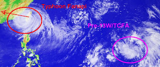
Typhoon Fanapi (12W/Inday)
- 23.7N 121.6E
- 148.16 km. South of Taipei, Taiwan
- now made on it's landfall
- currently moving westward @ 26 kph
- maximum sustained winds: 195 kph
- gustiness winds: 241 kph
- Saffir-Simpson Typhoon Scale: Category 2
- minimum sea level pressure: 952 MB
- maximum sea wave height: 28 feet
- heading towards Taiwan Strait-Southeastern China
Typhoon Fanapi weakens it's strength as it made its landfallo ver the Eastern coast of Taiwan downgraded in to Category 2 disturbance. It is anticipated to resume its westward track this afternoon and will be expected to be in Taiwan Strait later tonight with the maximum sustained winds of 165 kph. Stormy weather with thunderstorm and storge surge is expected to affect across the island nation. Typhoon Finapi is expected to make it's landfall over Southeastern China later tomorrow morning and shall dissipate as low pressure over Guandong Province area.
Tropical Cyclone Formation Alert 90W/Pre-13W - 13.9N 151.2E
- 675.98 km. East ofGuam
- currently moving westward @ 28 kph
- maximum sustained winds: 28 kph
- gustiness winds: 37 kph
- Saffir-Simpson Typhoon Scale: Tropical Disturbance
- minimum sea level pressure: 1007 MB
- maximum sea wave height: n/a
No comments:
Post a Comment