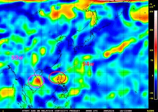

Tropical Disturbance 94w
- 19.1N 119.8E
- maximum sustained winds: 28 kph
- gustiness winds: 37 kph
- minimum sea level pressure: 1008 MB
- 290 nm North of Manila, Philippines
Tropical Disturbance 94w has persisted and tracked to pass at Babuyan Island, over the Northern Luzon Strait today. Latest satellite imagery shows the system is moving under a region of increasing diffluence associated with the southwest side of the subtropical ridge which is forecast to reorganize after the passing area and consolidates more strength. Based also to the latest numerical weather guidance models issue, there is a big possibility that this will become an active cyclone in the next 12-36 hours. More datas justify the possible formation over the South China Sea as ECMWF (European Center MediumWeather Forecasts) runs this system in to NW-WNW direction towards East of Hainan and Southern China. The said system is embedded along the Inter-Tropical Convergence Zone which greatly affect most part of the archipelago. Tropical Disturbance 94w is projected to dump rains as it gains strength associated with thunderstorms across Northern Luzon.


No comments:
Post a Comment