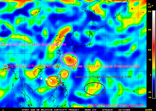
Tropical Depression 91W
- 15.5N 117.0E
- 315 km East of Iba, Zambales
- maximum sustained winds: 55 kph
- gustiness winds: 75 kph
- minimum sea level pressure: 1010 MB
- Saffir-Simpson Typhoon Scale: Tropical Depression
- currently moving westward slowly
- heading towards South China Sea
Tropical Depression 91W is expected to gain more strength and will become Tropical Storm early morning tracking WNW towards South China Sea. If this scenario will continue within the next 12-24 hours, it will not affect instead it would enhance the Southwest Monsoon that could affect Western Luzon down t6o Palawan area.
Tropical Depression 99W - 26.0N 127.4E
- near Okinawa, Japan
- maximum sustained winds: 55 kph
- gustiness winds: 75 kph
- minimum sea level pressure: 1008 MB
- currently moving NNW @ 20 kph
- 9.0N 142.0E
- 1,720 km East of Northern Mindanao, SW of Guam
- maximum sustained winds: 30 kph
- minimum sea level pressure: 1010 MB
- currently moving WNW slowly
- 20.5N 1w1.6E
- 40 km West of Basco, Batanes
- maximum sustained winds: 25 kph
- minimum sea level pressure: 1010MB
- currently moving NW @ 25 kph
No comments:
Post a Comment