Sunday, August 15, 2010

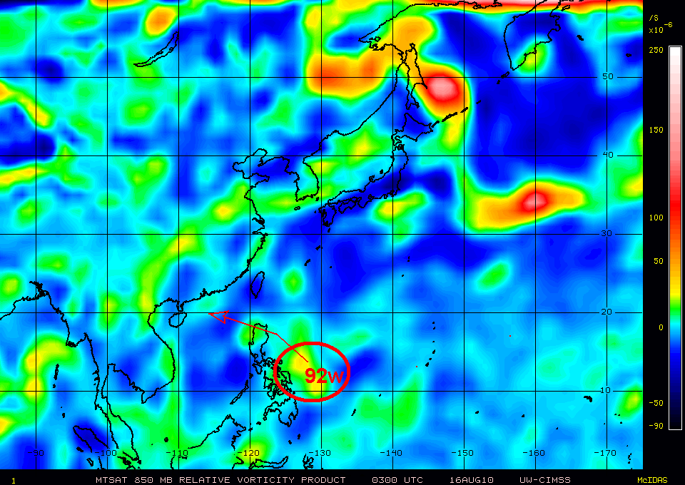
Tropical Disturbance 92w rapidly developing as Tropical Cyclone Formation Potential is at 35-55%...ITCZ afffecting the country


Tropical Disturbance 92W
  • 14.o N 128.0E
  • moving westward @ 21 kph
  • 1010 MB
  • about 410 km East of Bicol Region
The latest Hong Kong Computer Models, used in predicting active disturbance or cyclone forecasts this system, 92w. invest to affect the Northern Luzon. The 2-3 day long range forecast shows this disturbance to peak the minimum sea level pressure characteristic of weak Tropical Depression having 1004 MB. The said disturbance is expected to move in WNW-NW and change its course in westward direction heading Cagayan-Northern Isabela area tomorrow, August 17, 2010. It is expected to pass Northern Luzon and exit via Ilocos Norte heading South China Sea. More weather updates as this rapidly developing disturbance might affect the northermost part of the country.

Inter-Tropical Convergence Zone remains the dominant active weather disturbance affecting the archipelago that will bring isolated rains and thunderstorms.

Sunday, August 8, 2010

Tropical Storm Dianmu forecasts to track South Korea... 99w develops near Yap Is. ...40% of becoming an ctive cyclone


As of 12 p.m
Warning Information #3
________________________________________________________________
Tropical Storm Dianmu/05w
________________________________________________________________
Other Agency's:

+ JTWC - 65kph
+ JMA - 65 kph
+ PAGASA-85 kph
----------------------------------------------------------------
Location:25.6N 125.6E
Distance:
640 km NE of Basco, Batanes
Movement:North @ 19 kph
Maximum Sustained winds:65 kph
Gustiness Winds:85 kph
Saffir-Simpson Typhoon Scale:Tropical Storm
Dvorak Description Scale:Stage 5 (Strong Tropical Storm)
Minimum Sea Level Pressure:996 MB
Projected Path:South Korea
Philippine Public Warning Storm Signal#1:
Batanes Group of Islands
-----------------------------------------------------------------
Cyclone Forecasts Analysis and Observation:

Tropical Storm Dianmu is expected to track N-NNE within the next 24-36 hours as it was affected by the strong High Pressure Area near Eastern Japan. Dianmu is expected to hit Wednesday afternoon with the wind speed 0f 85 kph. It then moved near Sea of Japan Thursday afternoon and become an Extra-Tropical Cyclone.

Tropical Storm Dianmu is expected to bring moderate to heavy rainfall with thunderstorms along the projected are.


Tropical Disturbance Watch

Tropical Disturbance 99w
  • 8.5N 138.0E
  • westward @ 20 kph
  • 30 kph near the center

Saturday, August 7, 2010

Tropical Depression 96w gains more strength as it moves away from the Philippines


As of 1 p.m
Warning Information #3
________________________________________________________________
Tropical Depression 05W/96W
________________________________________________________________
Other Agency's:

+ JTWC - 45kph
+ JMA - 55 kph
+ PAGASA - 55 kph
----------------------------------------------------------------
Location:22.3N 124.7E
Distance:380 km. East of Basco, Batanes
Movement:NE @ 15 kph
Maximum Sustained 74 kph
Saffir-Simpson Typhoon Scale:Tropical Depression
Dvorak Description Scale:Stage 1 (Weak Depression)
Minimum Sea Level Pressure:1000 MB
Projected Path:Okinawa Area
Philippine Public Warning Storm Signal#1:
BATANES GROUP OF ISLANDS, CALAYAN ISLAND, CAGAYAN, AND BABUYAN ISLANDS
-----------------------------------------------------------------
Cyclone Forecasts Analysis and Observation:

The following are extended forecasts outlook for Tropical Depression 96W/05W:

12 hours 24.1N 125.6E 56 kph-74 kph Tropical Depression
24 hours 26.3N 126.2E 56 kph-74 kph Tropical Depression
36 hours 28.4N 126.4E 65 kph-83 kph Tropical Depression

Tropical Depression 05w is expected to intensify within the next 24 hours tracking Okinawa, Japan. The said disturbance is expected to enhance the Southwest Monsoon. It is anticipated to bring moderate to heavy rains along the affected area with thunderstorms.

24.1N 125.6E

Tropical Depression 96w remains quasi-stationary but forecasts to move NW-WNW heading Okinawa,Japan


As of 7 p.m
Information #1
________________________________________________________________
Tropical Depression 96W/05W
________________________________________________________________
Other Agency's:

+ JTWC - 35kph
+ JMA - 35 kph
+ PAGASA - 55 kph
----------------------------------------------------------------
Location:19.2N 125.1E
Distance:270 km. East of Basco, Batanes
Movement:Quasi-Stationary
Maximum Sustained winds:46 kph
Gustiness Winds:65 kph
Saffir-Simpson Typhoon Scale:Tropical Depression
Dvorak Description Scale:Stage 1 (Weak Tropical Depression)
Minimum Sea Level Pressure:1004 MB
Projected Path:Batanes-Eastern Taiwan coast
Philippine Public Warning Storm Signal#1:
Cagayan, Apayao, Kalinga, Abra, Ilocos Norte, Ilocos Sur, Northern Isabela, Batanes-Babuyan- Calayan Island
-----------------------------------------------------------------
Cycl
one Forecasts Analysis and Observation:

Tropical Depression 96w is expected to remain quasi-stationary
within the next 6 hours and forecasts to track Northwest-West Northwestward in the next 12-24 hours. The said disturbance will bring moderate to heavy rainfall with thunderstorms along the affected area. Due to this disturbance, it will continue enhancing the strong Southwest monsoon affecting most of all the parts of the country.

Friday, August 6, 2010

Tropical Disturbance 96w might become Tropical Depression within the next the 12-24 hours


As of 12 a.m
Warning Information #1
________________________________________________________________
Tropical Disturbance 96W/Pre-05W
________________________________________________________________
Other Agency's:

+ JTWC - 19 kph-29 kph(10-15 knots)
+ Navy Tropical Cyclone Page -37 kph (20 knots)
----------------------------------------------------------------
Location:19.5N 126.2E
Distance:270 Km EastSouthEast of Basco, Batanes
Movement:moving west @ 22 kph
Maximum Sustained winds:37 kph
Gustiness Winds:46 kph
Saffir-Simpson Typhoon Scale:Tropical Disturbance
Dvorak Description Scale for the next 12 hrs: Stage 1 (TCFA)
Minimum Sea Level Pressure:1006 MB
Projected Path:Batanes-Taiwan area

-----------------------------------------------------------------
Cyclone Forecasts Analysis and Observation:

Tropical Disturbance 96w is expected to organize within the next 6-12 hours as it moves toward an area of favorable upper level divergence and weak vertical wind shear. Based on its latest current movement, it is expected to pass over Batanes and Taiwan area early or late tomorrow morning peaking the wind speed of Tropical Depression strength. The said disturbance is expected to pull and enhance the Southwest Monsoon that almost affecting all parts of the country. The latest satellite imagery shows 96w bringing moderate to heavy rains and thunderstorms.

*Watch out for the latest weather updates and details as this this system will closely monitored for further development.

ECMWF forecasts a Tropical Disturbance transversing Northern Visayas starting tomorrow


European Center for Medium-Range Weather Forecasts (ECMWF) -a well- known weather agency has forecasts a developing Tropical Disurbance. The 2-3 long range day forecasts is expected to move in Northern part in Western Visayas on Saturday and move a little bit Southwest direction towards South China on Sunday (expected to be near Northwest of Palawan. This forecast disturbance is expected to bring moderate to heavy rainfall with thunderstorms as it is embedded along the active Inter-Tropical Convergence Zone. This wil laffect the Southern Luzon, Bicol Region, Visayas and Mindanao as this will enhance the Southwest Monsoon (Hanging Habagat).

Monday, August 2, 2010

Tropical Cyclone Formation Potential for 96w is now 45%-65%...ITCZ affecting Visayas and Mindanao


As of 8 p.m
Information #1
________________________________________________________________
Tropical Disturbance 96W
________________________________________________________________
Other Agency's:

+Navy Tropical Cyclone Page-28 kph
----------------------------------------------------------------
Location:8.8N 134.7E
Distance:990 km East of Northern Mindanao
Movement:West
Maximum Sustained winds:28 kph
Gustiness Winds:37 kph
Saffir-Simpson Typhoon Scale:Tropical Disturbance
Dvorak Description Scale:Stage 1 (Warning)
Minimum Sea Level Pressure:1006 MB
Projected Path: Philippine Sea

-----------------------------------------------------------------
Cyclone Analysis and Observation:

Tropical Disturbance 96w remains embedded along the active Inter-Tropical Convergence Zone that affects Visayas and Mindanao.It is expected to move as Japan Meteorological Agency forecasts this system not moving/stationary for the past 6 hours. More weather bulletin will be issued once this system will develop in to an active that could affect the country.