Thursday, November 25, 2010

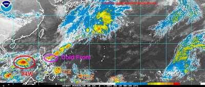
Tropical Disturbance 94W moves toward Southern Vietnam..Tail-end of a Cold Front affecting Bicol Region

Based on the latest weather satellite imagery, Tail-end of a Cold Front affecting the Eastern Luzon and Bicol region. This region will experience mostly cloudy skies with isolated to scattered rains. showers and thunderstorms. Northeast Monsoon remains the dominant  disturbance that  brings cold weather temperature in Extreme Northern Luzon
* Residents along Mount Bulusan are alerted from possible lahar flows as possible rains that might trigger landslide along the mountain slope.

While weak to moderate Easterlies Wave now heading towards Eastern Mindanao. Possible rainshowers with thunderstorms also are expected as it moves toward Northern Mindanao and Southern Visayas.

Tropical Disturbance 94W remains disorganized as it moves toward Southern Vietnam. Possible intensification within the next 12 hours is still at 15%-25% (low chances).
Monday, November 1, 2010

PAG-ASA made an excellent job in tracking Typhoon Megi in the Philippines

PAG-ASA made a better job when they forecasts the expected projected landfall, bulletins and models during Tropical Cyclone Megi lashes Northern Luzon. Here are the total votes casted after the 10 days. More visitors rather to gave a positive score for PAG-ASA since they issued early warnings and bulletins before Typhoon Megi devastated Northern part of the country.


Enhanced by Zemanta

Government needs to provide a budget for this agency in order to have world-class facilities and instruments in order to provide an excellent weather forecasting in the science of meteorology.

We do hope that this better performance will improves not only today but in the near future.